-
Clean Colorado Sustainability Coalition
2330 McCulloch Blvd. N.
Lake Havasu City, AZ 86403
Phone: (928)453-4152
contact
What's Current
Lake Havasu Topography Mapping Project Update

Click on image above for very large version
Download .zip of Lake Havasu Topography Mapping Project as Shapefile for use with ARCGIS
Lake Havasu Topography Mapping Project
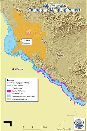
Download .pdf of Lake Havasu Topography Mapping Project
Water Management Plan
Download .PDF of Watershed Management Plan
Lower Colorado River Water Quality Data Collection
Water quality data on the Lower Colorado River is continuing to be collected through monitoring efforts of various CCRSCo members, Bureau of Reclamation, and Arizona Department of Environmental Quality. Much of this data is also added to the Southern Nevada Water Authority’s database and is accessible through a password protected portal for interested parties.
Lake Havasu Bottom Topography Sounding Project
The CCRSCo Board authorized a $10,000 grant in January 2016 to Arizona State University Colleges at Lake Havasu to kick-start a research program on Lake Havasu and adjacent reaches of the Colorado River. The specific project proposed is a comprehensive bathymetric and imaging survey of the reservoir bottom. The intent of the project is to determine the reservoir’s geometry, which will be used in further research of other reservoir properties and processes, and computer modeling of river/reservoir system. Specifically, a detailed topographic map of the reservoir bottom will be generated along with 3-D imaging of the bottom in the hope to resolve various attributes, including the remnants of the old Colorado River riparian corridor prior to its impoundment, cut banks of the river channel, aquatic vegetation distribution and density, reservoir bottom substrate type, and various cultural and historic features that are known to lie on the bottom.
Cooperative Watershed Management Program Grant
CCRSCo received in June 2016 a Cooperative Watershed Management Program grant through Bureau of Reclamation’s WaterSMART Program with the purpose over the next two years to expand and diversify its membership and to develop a watershed management plan for a good portion of the Lower Colorado River main stem. CCRSCo is looking to expand its membership in order to include a larger variety of stakeholders that either have a direct dependence on the river or have a keen interest to sustainably manage good water quality in the river system. Potential new members could represent agriculture, aquatic recreation (boating and fishing) concerns, businesses, and environmental organizations. Other new members that will help strengthen existing member concerns include tribal interests, water providers, academic interests, and other local/regional government entities.
The recruiting process for new members is envisioned to be timed with the development of the second part of the grant, development of an USEPA approved watershed management plan. A watershed management plan identifies existing and potential concerns within a watershed that threaten or are actively degrading the health of the watershed. The plan is expected to cover two large hydrologic units on the Colorado River that are recognized by the U. S. Geological Survey and the USEPA. (Havasu-Mohave Lakes and Imperial – see map below). These two hydrologic units span the length of the Colorado River from Lake Mohave south to the Imperial National Wildlife Refuge. They were selected as existing CCRSCo members either occupy or have working interest along this stretch of river. A selected consulting firm will work on the plan, but they will need input from as many view points as possible to ensure a strong, comprehensive management plan. This is one reason for the need to diversify CCRSCo membership. This project will include a public comment component and is expected to be completed by July 2018.